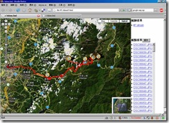
20080412阿里山出遊路線分享(I-gotU GT-100)
[旅程中2個大斷層,跟沒結尾的冏況,所以出現大橫貫與圖片辜兒等精采結局請勿受到驚嚇]step 1. 安裝i-gotU Desktop
step 2. 將 *.mdb(Link) 放至 C:\Documents and Settings\******\Application Data\MobileAction\GPSTracer 取代 Tracer.mdb
step 3. 選取兩筆track→合併
---------- (分隔線)繼續下列步驟或匯出*.gpx(Link)使用其它軟體後製(edit、gpscoding、gpstagging…)---------
step 4. 於下方的"相簿"右鍵→新增圖片
step 5. 選取圖片右鍵→儲存GPS
step 6. 點選上片track 會重新載入Google Map(Ps. i-gotU Desktop圖片太多(大)可能會當)
step 7. 匯出html,gpx,kml…

(相關討論請參考:[Mobile01分享]i-gotU(GT-100)旅程紀錄 或 i-gotU操作手冊)
Geocode aware
GPicSync:Automatically geocode pictures from your camera and a GPS track log.
Picasa:
Picasa is a software application for organizing and editing digital photos, Google began offering Picasa for free download.
Google Earth:
Google Earth lets you fly anywhere on Earth to view satellite imagery, maps, terrain, 3D buildings and even explore galaxies in the Sky. You can explore rich geographical content, save your toured places and share with others.
Friendly.Flickr:
一個整合Flickr上下傳的編輯工具
Geotagging Albums
(Demo)


(DEMO)


(DEMO)
上傳圖片前先注意有無允許自動匯入GPS資訊(否則就要手動調整囉)You→Your Account→Privacy & Permissions→Import EXIF location data


也有第三方做的 http://kmlphotos.metaltoad.com/

點選


(DEMO)
整體來說還有很大的進步空間…
整合Flickr與 Urmap與Google Map/Earth
(來源請參考:UrKML / UrGPX照片軌跡整合線上地圖的小工具)匯出KMZ

Flickr with Google Earth

KML with Google Map(DEMO)

Flickr with Google Map(DEMO)
1: 5mi

1:2000ft

Flickr with Urmap(DEMO)
1:6.4km

1:200m

Editor
JOSMFile→Open→*.gpx

使用Google Map圖資
(Ps.基本上空照圖是要收費的,所以大部份OpenSource是沒有空照圖的)


左手邊垃圾桶按鈕→刪點

(隨便玩玩~呵) 繞圈圈


Desktop Componet
swinglabs > swingx-ws > JXMapViewer

一些詞條 (Wikipedia)
GPS tracking:A GPS tracking unit is a device that uses the Global Positioning System to determine the precise location of a vehicle, person, or other asset to which it is attached and to record the position of the asset at regular intervals. The recorded location data can be stored within the tracking unit, or it may be transmitted to a central location data base, or internet-connected computer, using a cellular (GPRS), radio, or satellite modem embedded in the unit. This allows the asset's location to be displayed against a map backdrop either in real-time or when analysing the track later, using customized software. Such systems are not new; amateur radio operators have been operating their free GPS based nationwide realtime Automatic Position Reporting System since 1982.
Data loggers:
A GPS logger simply logs the position of the device at regular intervals in its internal memory. Modern GPS loggers have either a memory card slot, or internal flash memory and a USB port. Some act as a USB flash drive. This allows downloading of the data for further analysis in a computer.
GPX:
GPX, or GPS eXchange Format is an XML schema designed for transferring GPS data between software applications. It can be used to describe waypoints, tracks, and routes. The format is open and can be used without the need to pay licence fees.
Geotagging:
Geotagging, sometimes referred to as Geocoding, is the process of adding geographical identification metadata to various media such as websites, RSS feeds, or images and is a form of geospatial metadata. This data usually consists of latitude and longitude coordinates, though it can also include altitude, bearing, and place names.
Geocode:
Geocoding is the process of assigning geographic identifiers (e.g., codes or geographic coordinates expressed as latitude-longitude) to map features and other data records
Waypoint:
Waypoints are sets of coordinates that identify a point in physical space. For the purposes of terrestrial navigation, these coordinates usually include longitude and latitude, and sometimes altitude (particularly for air navigation).
Track、Route:
An ordered collection of points may be expressed as a track or a route. Conceptually, tracks are a record of where a person has been, routes are suggestions about where they might go in the future. So, for instance, there might be timestamps for each point in a track (because someone is recording where and when they were there), but timestamps for each point in a route are unlikely to be provided, because the author is suggesting it, and nobody might ever have travelled it.
KML:
Keyhole Markup Language (KML) is an XML-based language schema for expressing geographic annotation and visualization on existing or future Web-based, two-dimensional maps and three-dimensional Earth browsers. KML was developed for use with Google Earth, which was originally named Keyhole Earth Viewer. It was created by Keyhole, Inc, which was acquired by Google in 2004. The name "Keyhole" is an homage to the KH reconnaissance satellites, the original eye-in-the-sky military reconnaissance system first launched in 1976.
KMZ:
KML files are very often distributed as KMZ files, which are zipped KML files with a .kmz extension